Maps, apps & guides
Network Maps
Timetables and Real Time Information
All bus stops, train stations, and ferry wharves have posted timetable and route information at the stop, and many have digital real time departure displays. We recommend using the Metlink app(external link) or mobile website for the most up-to-date route and timetable information, real time service alerts and live departures.
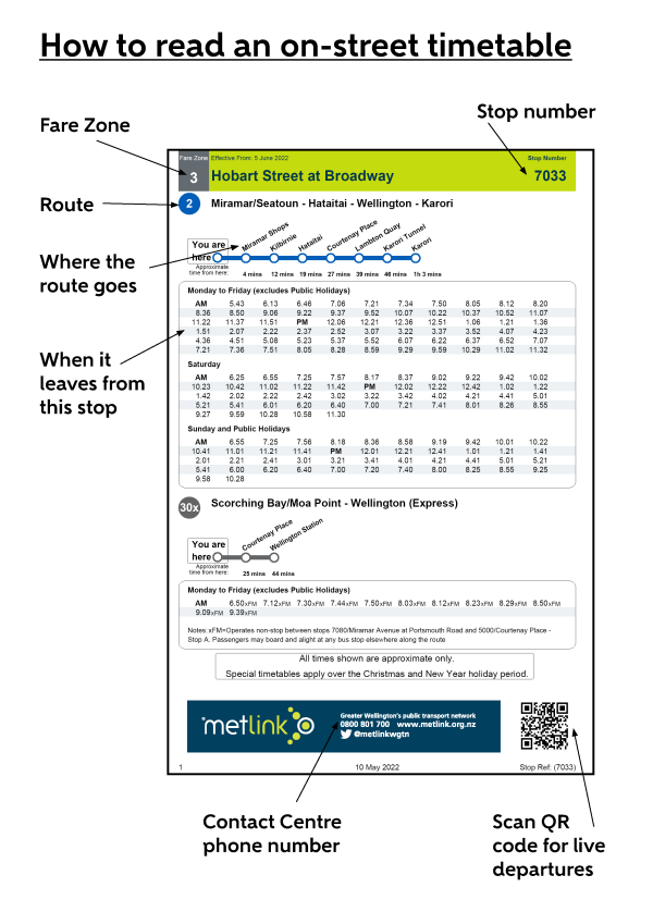
Routes and stop departure times are posted at all bus stops, train stations & ferry wharves, and include zone information and a graphic detailing the main stops and estimated travel times of routes. Some stops have digital real time information displays. If the stop does not have a digital display, you can scan the QR code in the bottom-right corner to see that stop's real time departure information or type the stop number or station name into the Metlink app or website to see estimated departures.
 Network maps are posted at all train stations and major bus interchanges. Network maps can also be viewed or download from the website, and paper versions are available at Wellington Station, the Wellington iSite, and other timetable stockists around the region.
Ways to get a paper timetable:
- Download and print directly from the Metlink website by clicking the "download" button on any online timetable.
- Visit a timetable brochure stockist. Find the locations on the Metlink home page map by selecting "Timetables & Maps" from the map menu options, or see the list of locations below.
- Request paper timetable to be mailed to you by calling the Contact Centre or filling out the online request form.
Information Centres & Shopping Centres
- Wellington City i-Site
- Martinborough i-Site
- Masterton i-Site
- Queensgate Shopping Centre, Lower Hutt
Council Offices
- Greater Wellington Regional Council offices - Cuba Street, Wellington
- Greater Wellington Regional Council offices - Masterton
- Porirua City Council - Reception
Train Stations
- Wellington Station(external link) Customer Kiosk
- Petone Station(external link)
- Waterloo Station(external link)
- Upper Hutt Station(external link)
- Masterton Station(external link)
- Porirua Station(external link)
- Paraparaumu St(external link)ation
- Waikanae Station(external link)
Bus Operator Depots
- Kilbirnie Bus Depot
Hospitals & Universities
- Te Herenga Waka - Victoria University Kelburn campus
- Wellington Regional Hospital
- Hutt Hospital
- Kenepuru Community Hospital
Libraries & Community Centres
- Brooklyn Library
- Churton Park Community Centre
- Island Bay Library
- Karori Library
- Khandallah Library
- Kilbirnie (Ruth Gotlieb) Library
- Miramar Library
- Newlands Community Centre
- Newtown Library
- Ngaio (Cummings Park) Library
- Tawa (Mervyn Kemp) Library
- Wadestown Library
- Lower Hutt War Memorial Library
- Upper Hutt Library
- Eastbourne Library
- Moera Library
- Naenae Library
- Petone Library
- Stokes Valley Library
- Taita (Walter Nash Centre) Library
- Wainuiomata Library
- Carterton Library & Information Centre
- Featherson Library
- Greytown Library
- Porirua Library
- Cannon's Creek Library
- Paraparaumu Library
- Waikanae Library
- Ōtaki Library
Metlink use a vehicle tracking system to estimate arrival times of services based on actual GPS locations of buses and trains, called Real Time Information (RTI). On-street digital displays are also used to provide messages advising of major service changes or disruptions. The tracking information collected from the system provides us with data about service performance, which helps us refine timetables and manage contractual agreements around service quality and performance.
Many of the busiest bus stops and most train stations have digital departure displays on street or on the platform. Departure times for each stop, even if it doesn't have a digital display, can be found on the Metlink website and app by typing in the stop name, stop number or station name in the search bar.
Understanding the information
Buses and trains that are running and tracked by GPS will display as an estimated number of minutes to arrival. DUE means the bus or train is nearby and will turn up shortly. Services that have not started their trip or are not currently being tracked by GPS will display as a scheduled time and say SCHED. If a service says CAN, it has been cancelled.
Train services will display if a train is running "All stops" or "Express". When buses replace trains, signage will display a system message with more information.
Service alerts and delay messages are broadcast to customers through several channels. The Metlink website and app and scrolling messages on on-street digital signage will inform customers if their service has been impacted. Delay messages and general service alerts are not usually posted to facebook. Train stations may also play announcements over loudspeakers.
Please note: Third-party apps and other websites that "scrape" our website for timetables, routes, and real-time information may not accurately or reliably display all of the service alerts and notifications that Metlink publishes. Metlink does not have control of the quality of information that other apps provide. Contact your app provider directly with any issues.